

Introduction
This article describes how to get the latitude and longitude of a location using the Google Map API in ASP.Net. Here I will describe how to communicate with the Google Map API.
Description
To use the Google Map API you need to add the following link to the Head section.- <script type="text/javascript" src="https://maps.googleapis.com/maps/api/js?sensor=false"></script>
Now add two TextBoxes, one Button, and one Label.
Design your screen as in the following screen.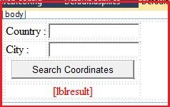
Or you can copy the following source code:
- <body>
- <form id="form1" runat="server">
- <div>
- <table>
- <tr>
- <td>
- Country :
- </td>
- <td>
- <asp:TextBox ID="txtCon" runat="server"></asp:TextBox>
- </td>
- </tr>
- <tr>
- <td>
- City :
- </td>
- <td>
- <asp:TextBox ID="txtCity" runat="server"></asp:TextBox>
- </td>
- </tr>
- <tr>
- <td colspan="2" align="center">
- <input id="btn" type="button" value="Search Coordinates" />
- </td>
- </tr>
- <tr>
- <td colspan="2" align="center">
- <asp:Label ID="lblresult" runat="server" ForeColor="Red"></asp:Label>
- </td>
- </tr>
- </table>
- </div>
- </form>
- </body>
- <script src="jquery-1.9.1.js" type="text/javascript"></script>
- <script type="text/javascript" src="https://maps.googleapis.com/maps/api/js?sensor=false"></script>
- <script type="text/javascript">
- $(document).ready(function () {
- $("#btn").click(function () {
- var geocoder = new google.maps.Geocoder();
- var con = document.getElementById('txtCon').value;
- var city = document.getElementById('txtCity').value;
- var res = document.getElementById('lblresult');
- var com = city + "," + con;
- geocoder.geocode({ 'address': com }, function (results, status) {
- if (status == google.maps.GeocoderStatus.OK) {
- res.innerHTML = "Latitude : " + results[0].geometry.location.lat() + "<br/>Longitude :" +
- results[0].geometry.location.lng();
- } else {
- res.innerHTML = "Wrong Details: " + status;
- }
- });
- });
- });
- </script>
Now build your application. Enter a City and Country in the respective text boxes then press the button.
It will show the latitude and longitude of that place in the label.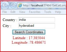
Thank you.
Jithin SunnyPosted Dec 21, 2018, 12:55 AM
This answer is now out-of-date. You are now required to have an API key to use google maps.
Nicola HannaPosted Jun 10, 2015, 3:12 AM
Why does the label display and then disappear again? and how do I stop it doing that?
Vithal WadjePosted Oct 7, 2013, 12:56 PM
good,keep it up
Preeti AgrawallaPosted Sep 7, 2013, 7:00 AM
nice .....